Scafell Pike from Seathwaite

24 11 2012

Between Summer 2011 and Summer 2012 I climbed Scafell Pike over 60 times, and it was due to this that I have been known to say that I would never climb Scafell Pike without a group ever again….today I suprised myself! When I first started walking I did a lot of Solo walking, and it is something that today, for the first time in a long time, I could enjoy again. I think having some time to yourself each day, week or month is very important. It gives you a chance to sort out your thoughts and just think, or not think.

Before today I had not climbed Scafell Pike since August and despite thinking I would probably choose dozens of routes over Scafell Pike for a social escapade, I wanted to get back up to that summit! I had a look at the weather forecast, and with phrases such as ‘Excellent Visibility’, ‘no Rain’, I knew it would be a fine day to head up England’s Highest!

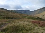
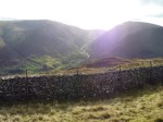
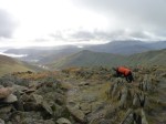
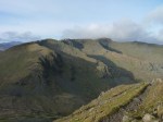
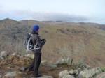
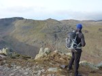
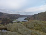
Today was also a momentous occasion as it was Lexi’s first ascent of Scafell Pike! Wee started from Seathwaite and an impressive blanket of cloud was spilling into the valley. We made our way up to Styhead Pass where we got our first sighting of a snow capped Scafell Pike. We joined the Corridor Route and enjoyed a good climb in suprisingly mild conditions. As we crossed the top of Piers Gill we were seeing more and more snow, which is still a quite an alien thing to Lexi!

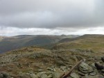
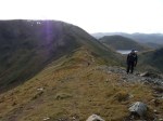
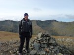
The snow got thicker and thicker as we climbed up, but soon enough we were on the busy summit! We enjoyed the views and some lunch on top, and Lexi ran around hoovering up the scraps (everyone elses lunches!) We left the summit and made our way down the steep slope to Broad Crag Col. We then enjoyed the two consecutive tops of Broad Crag and Ill Crag. As we reached Calf Cove Lexi decided to have a mad 5 mintues and run around in the snow.

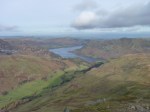
We finished off our walk with a nice descent down Grains Gill back to Seathwaite Farm.

Keen to Climb Scafell Pike? Next Year Lakeland Mountain Guides has it on their Diary Loooooaddds!!!

This slideshow requires JavaScript.


Buttermere to Braithwaite via the Tops

16 11 2012

To round off a fantabulous week of walking we had the opportunity to do a linear walk. Last year myself and Clive enjoyed a scramble up the face of Grasmoor, and then walked across Eel Crag to Causey Pike, where we were fortunate enough to catch a beautiful sunset. Although we were not hoping to be so lucky with the sunset, we were keen do enjoy another Linear Walk, and bag a few Wainwrights along the way.

The lovely Clare (Clive’s partner) dropped us off at the base of Rannerdale Knotts by the shores of Crummock Water. Rannerdale Knotts looks like a small little lump from the roadside, but it is actually a steep little climb. As we climbed we feasted on the trademark view of Buttermere and its surrounding fells.

From the summit we walked southwards along its long spine to where it meets the steep path that heads up our second fell of the day, Whiteless Pike. The climb was a steep one, but an enjoyable one nonetheless. We didn’t stay long on it’s windswept summit and left along the impressive Whiteless Edge. As we neared the end of the ridge the mist started to lift off of some of the felltops, which gave us some hope that we would get some good views from the second half of the walk. From the top of the ridge we took a short walk across some grassy terrain to the summit of Wandope.

From Wandope we headed across a bit more grass and joined the main track that led us to the summit of Eel Crag, the highest summit of the day at 839m. Now ready for a bite to eat we descended off of Eel Crag, and just before summiting Sail we found some shelter and enjoyed some great views over lunch.

We descended from the summit of Sail and followed the track into the centre of the Coledale Horseshoe. For the last part of the walk we decided to walk over the three lovely fells in the middle of the valley. We started with Outerside, followed by Stile End and then finally Barrow. The views back up the valley, and down to Derwent Water from the summit of Barrow were outstanding as always. We stopped for a few minutes on the summit to soak it all up, as well as reflect on the great week of walking we had just had.

We left the summit of Barrow and made tracks for a pub in Braithwaite, a perfect way to finish off a great week! Thanks to Clive, Clare, Colin, Brian and of course Lexi!

This slideshow requires JavaScript.


The Whinlatter Fells

13 11 2012

ventoso, venteux, 風の強い, wietrzny, ανεμώδης….No matter how many different languages you say it in, it won’t sum up the weather today….It was flippin’ Windy!!!!

Our stomping patch for the day today was to be the Whinlatter Fells. Much like yesterday’s forecast, Wind was on the cards, but as we had some serious Wainwright bagging to do, we were up for it! We were dropped off by the lovely Clare at the Spout Force car park from which we descended down the hill into the valley. Our first fell was Graystones, and to reach it’s summit we had a very steep climb to contend with first. We plodded up the fell side and when we rounded on to its summit we were almost blown off it and down to Cockermouth! We fought our way to the summit cairn, and after grabbing a couple of quick shots in the gusting winds we took shelter behind a small wall.

After gathering ourselves, and laughing about how mad we were being out in this weather we made our way over to Broom Fell. Along the way we got some good shelter from a forest block, but once again as we started to near the summit we were leaning into the wind as we walked. We hid behind the summit cairn as we plotted the route ahead, and then cracked on once more.

From Broom Fell we took the ridge line to Lord’s Seat. As you can guess this was pretty windy but soon enough we made it to Lord’s Seat. On the summit there was a metal post in the ground, on which we decided to get a couple of  funny shots of us being blown away.

Our next fell was Barf, and to get to it we had to descend across some slightly boggy ground. We reached the summit and were rewarded with some lovely views over Bassenthwaite. We decided to stop here for a bite to eat.

From Barf we had to retrace our steps before contouring the fellside to reach Ullister Hill.  From this mound we were to make our way to our final summit of the day, Whinlatter Top. Now, as an honest blogger, I will let you know, this part of the day did not go quite as smoothly as the rest of it….. Without boring you, we got a little confused with some of the forest trails. We did manage to sort ourselves out and get back on track towards Whinlatter Top. As we neared this final summit the weather seemed to be closing in a bit more so we were keen to grab the summit and descend. Through the mist we reached the summit and then headed for the forest for shelter. A quick descent on good tracks brought us back to the Visitors Centre at Whinlatter where we were picked up by Clare (thanks Clare!)

A super windy, but epic day out on some quiet fells.

Matt Le Voi, Lakeland Mountain Guides

This slideshow requires JavaScript.


The Lesser Trodden Fells Behind Skiddaw

12 11 2012

South Westerly wind of about 40mph and gusts of up to 60mph….not a great thing to read when planning a walk, but there was hope! An area that I have not really explored, nor have the 3 gents that were walking with me today was behind Skiddaw, alternatively known as the Caldbeck Fells. The forecast was showing that the North Eastern area of the Lakes would have the better weather, and the large bulk of Skiddaw would provide us some shelter from the forecasted winds!

We met at Fell Side, a small little Hamlet situated on the northern edge of these fells. If you were just dumped in this area, you could easily think you were in Yorkshire and not the Lake District! We had a quick chat about our planned walk, edited a few bits and off we went. Within the first few hundred metres the day already got interesting as we needed to cross Dale Beck, a winding river that blocked our path onto the slopes of Brae Fell. After walking upstream for a few minutes we all found our own little crossing points, me opting for a risky run and leap off a stone in the middle of the river. Colin was more sacrificial and just waded through and accepted that he would have probably got wet feet during the day anyway!

We climbed up the north-east slopes of Brae Fell and were soon in the mist. Brae Fell, much like many fells in the Lakes always has more to give, and after a couple of false summits, we actually did reach the summit proper. The cloud started to part a little and we did have some views, but these were quickly gobbled up by some more mist.

We followed the good track south from the summit and skirted around Little Sca Fell onto the summit of Great Sca Fell. The walking along this part was fairly simple, and we were soon climbing up the northern slopes of Knott. We rounded onto our third summit just past midday, and we were already for a bite to eat. We opted to continue on to find some shelter from the wind and rain so we left the summit via its eastern slopes heading for the Cumbria Way.

This patch of fell was interesting as the paths on the map are not all on the ground, and what with the thick mist it made for some tricky navigation. We plodded on, and sure enough we found the correct paths and just before meeting the Cumbria Way we stopped for some munch out of the wind.

We joined the fine track of the Cumbria Way, and after a short while we came across the Lingy Hut, and basic Mountain Bothy. We explored inside, not that it took long, wrote in the guest book, and then cracked on our way northwards. Our original plan was to cut off eastwards at Hare Stones to ‘bag’ Carrock Fell, but as the weather wasn’t amazing, and what with shortening days, we opted to leave it for another time.

Soon enough we were on our final ascent up High Pike, and when we reached the summit we were greeted by a lovely memorial bench, which I am sure holds fantastic views on a good day. We left the summit and opted for some walking off of the beaten track. From the summit of High Pike we had a more or less un-obstructed walk across easy terrain back to our start point, so off we went. About half way back we were underneath the cloud and we were starting to see little bits of the route we had done throughout the day.

This walk is a lovely walk if you fancy some solitude on some lesser trodden tracks. Lakeland Mountain Guides does not have this on their diary, however if you wanted to do it then we are more than happy to arrange a day of private guiding for you!

This slideshow requires JavaScript.


Fairfield and St Sunday’s from Patterdale

11 11 2012

Fairfield from Patterdale  is a sensational walk, which I am sure is overlooked by many walkers every year. I personally find it holds more interest, and better views than the far more popular Fairfield Horseshoe.

We started in Patterdale and joined the long ridge that is Hartsop Above How. After just a a little while you are rewarded with fantastic views over Ullswater, and ahead to the planned route. The weather today was clear and bright with a little breeze, perfect for walking such a great route.

At the end of the ridge we climbed steeply onto Hart Crag where we were exposed to a slightly stronger wind. From this summit we gained some incredible views out westwards over the Lake District. From this summit we headed across to Fairfield, on which we had a bite to eat. It can’t have been much more than 2 degrees on the summit, so we didn’t stop for too long. We descended steeply down over Cofa Pike to Deepdale Hause where we had lovely views down the lesser trodden Deepdale Valley.

From the Hause we ascended up the long ridge that led to the summit of St Sunday’s Crag, where yet again we had amazing views all round, especially towards the Helvellyn Range. From the summit we descended down onto Birks and then over to Arnison Crag.

In total this route takes in 6 Wainwrights, so if you are keen to bag some, and have a fab day out, then this is a must do!